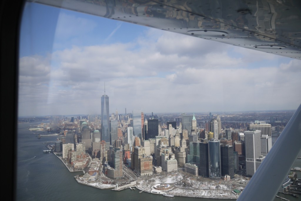
In my (freshly started) flying career, I have only a few items that are really on my bucket list in terms of things to go fly. One of those involves flying up the Hudson river, past New York City, using the Hudson River SFRA route (see the video above for an idea of what it is). I grew up in the New York City area, and the chance to see it by air is something that I’ve wanted to do for ages. Now that I have my private pilot’s certificate and an OpenAirplane checkout, I can finally go live that dream. But first, I need to plan it. And since I’m sure there are others planning to do the exact same flight, I figured I should share.
Academy of Aviation flight school at Republic Airport (KFRG) is an OpenAirplane operator, meaning that I can go rent their planes without needing a separate checkout first (which saves a TON of time and money). They have a beautiful Cessna 172R on the field that is pretty much like the plane I trained in, and perfect for the flight. So I contacted them, let them know what I wanted to do, and setup a reservation.
Something extremely helpful that they gave me was a little extra information specific to my flight. The OpenAirplane page for their operation includes a page on local procedures so I can understand the airspace a little better, but when I told them what I wanted to do they gave me some very specific information pertaining to exactly my route. Before I go into that, let me explain the SFRA.
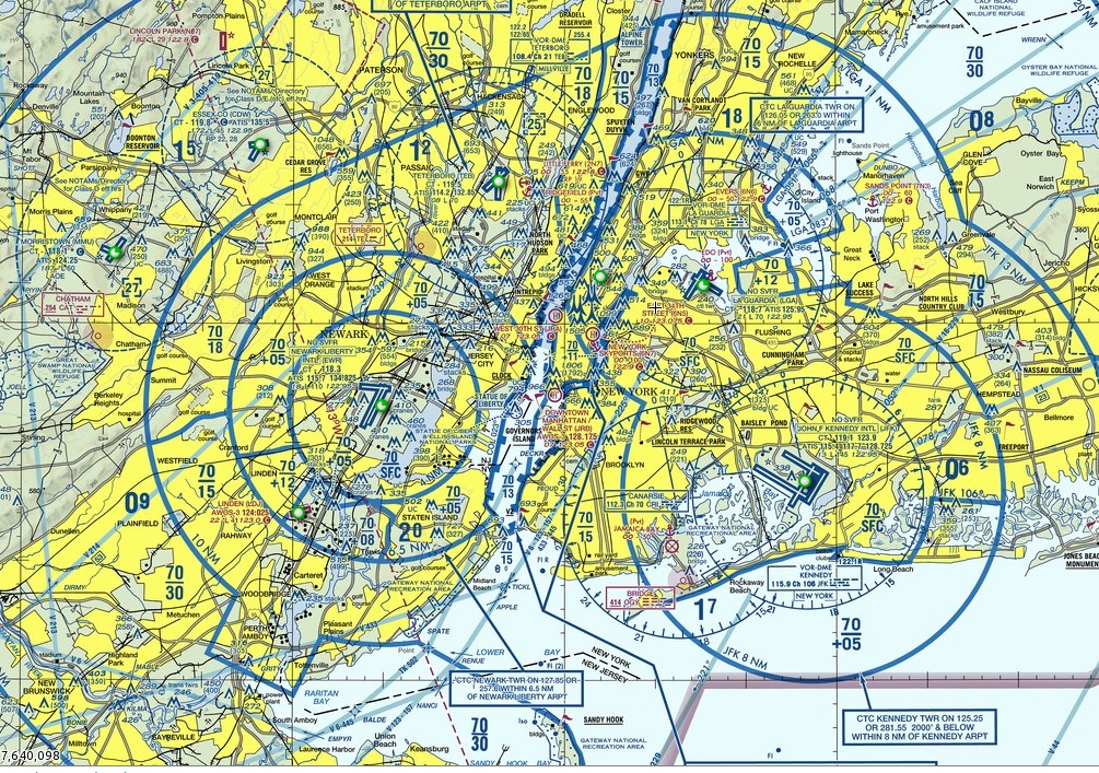
New York City has three exceedingly busy airports, and all three are in Class Bravo airspace. This Bravo pretty much covers the entirety of the city, and at its widest point covers 50 nautical miles from one side to the other. Getting anywhere close to New York City would be pretty much impossible except for one small detail: the Hudson River SFRA. Right down the middle of this massive and complex Bravo airspace, the Hudson River SFRA is a more or less uncontrolled VFR corridor stretching from the mouth of the Hudson River at the Verrizano Bridge nearly all the way up to the Tappan Zee in Westchester County. It provides a vital route for VFR traffic to pass through the area without bothering the already busy ATC controllers, and (more importantly) provides the ability to fly right next to the city itself with some amazing views.
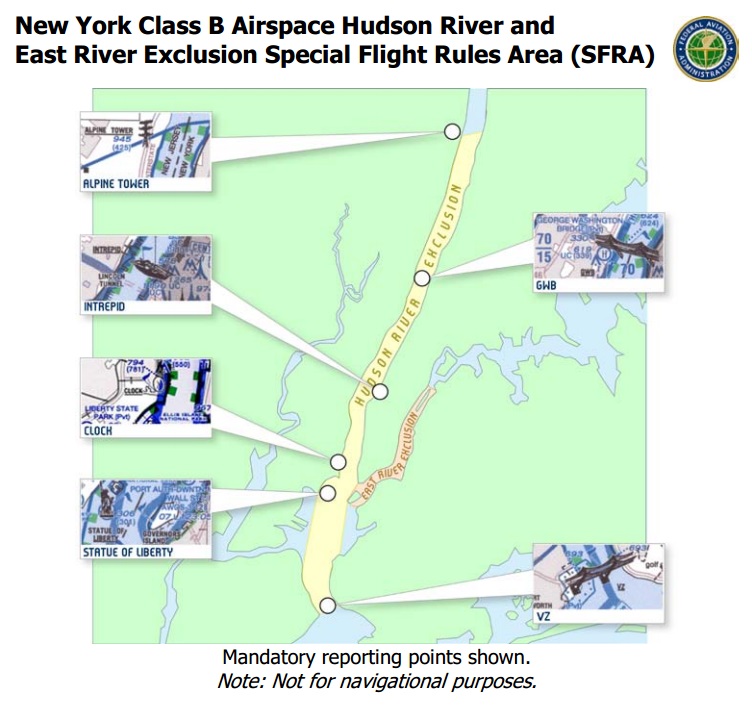
The SFRA is comprised of three sections:
- SFC to 999 Feet: Reserved for local traffic. Intended for helicopter tours and other local operations, this area sees heavy rotor-wing operations and isn’t ideal for fixed wing straight and level flight. In fact, before the SFRA was re-jiggered to include a layered approach, there was a nasty accident between a fixed and rotor wing aircraft.
- 1,000 to 1,299 Feet: Itinerant operations. Intended for fixed wing (or whirlybirds too, I suppose) this layer is designed to let traffic passing through the SFRA from one end to the other navigate with little concern for aircraft coming out of nowhere, except the helicopters entering the Bravo from below. Aircraft transition keeping to the right side of the river.
- 1,300 to 2,000 Feet (as assigned): Skyline Route. This layer is within the Bravo airspace, so requires a clearance from ATC to enter. It is controlled airspace so it should be a little safer, but the ability to use it is at the whim of the controllers at either end. Getting in isn’t guaranteed.
Because the SFRA is technically outside the Class Bravo airspace of any of the airports, operations below 1,300 feet are conducted on a CTAF (123.05) instead of operating with a controller. Clearances aren’t required to enter, but just like at an untowered airport you are required to announce your position and intentions. For itinerant flights especially, you are required to announce your aircraft type, altitude, location, and direction at a number of mandatory reporting points.
The idea is that pilots can understand the traffic surrounding them and maintain separation without controllers. Its all a little complicated, so the FAA has some requirements for anyone making the flight and some extra handy materials to help pilots out. First, a current copy of the New York City TAC and/or Helicopter Chart is required to be in the cockpit for the flight, and pilots are required to read and understand the entire thing. In addition, the FAA has a handy little printout that covers the basic procedures designed to be clipped to the pilot’s kneeboard for the flight (which I’m totally going to use). The third thing is something that I only realized when I contacted the flight school.
When I made the reservation, the flight school reached out by email to ask what my plan was. I told them that I wanted to fly the Hudson River SFRA, told them that I had a NYC TAC and Heli chart on order, and that I understood the rules, but if there was anything I was missing to let me know. They helpfully replied that there was actually a little 20 minute course on the FAA website specifically for the Hudson River SFRA, and suggested I give that a run before making the flight. To be honest, that course was extremely helpful in visualizing what was going on and how to fit in.
So, now I understood the SFRA and its requirements. The next problem was getting there.
As I said, the New York Class Bravo airspace is a pain in the ass.
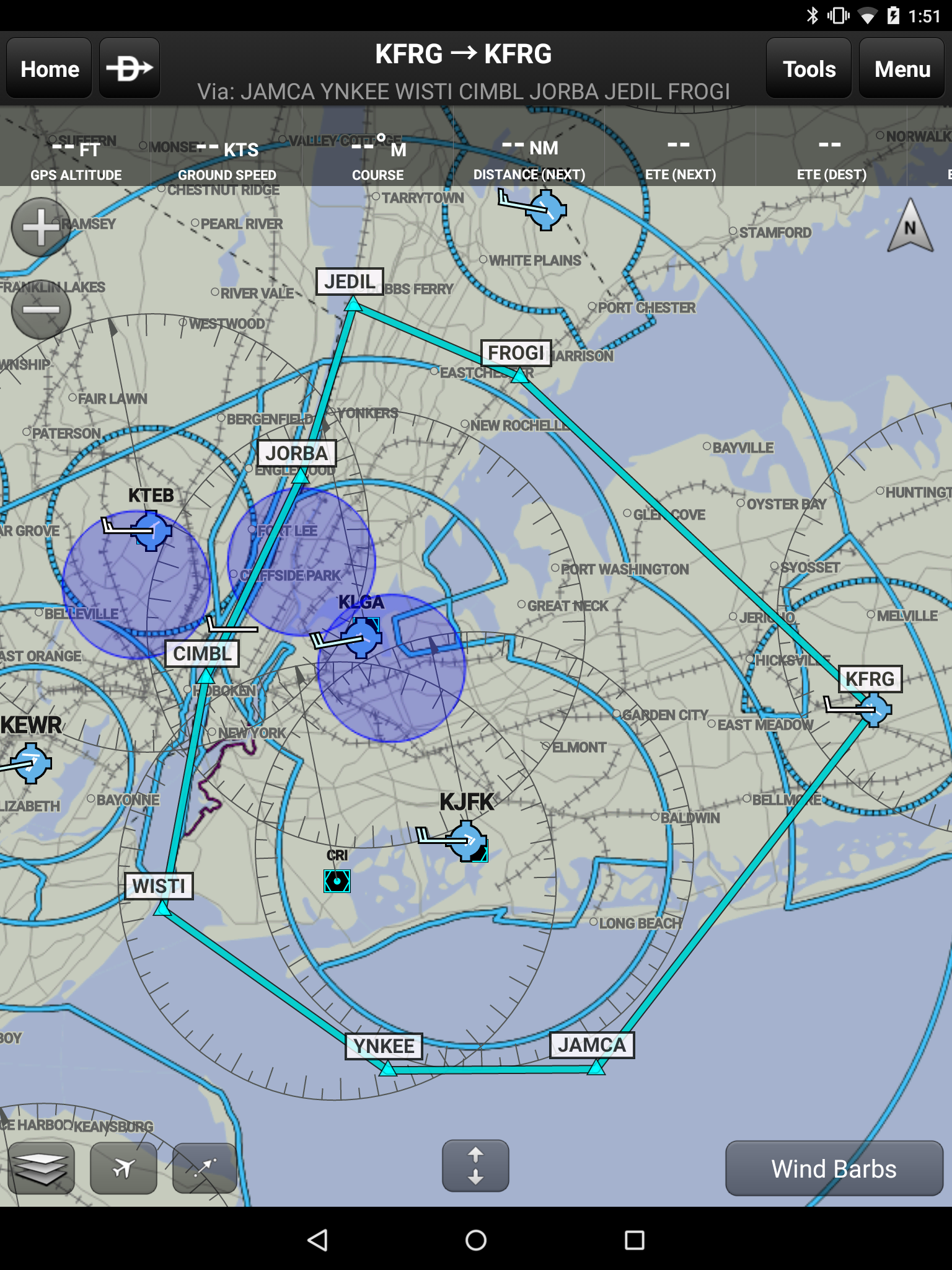
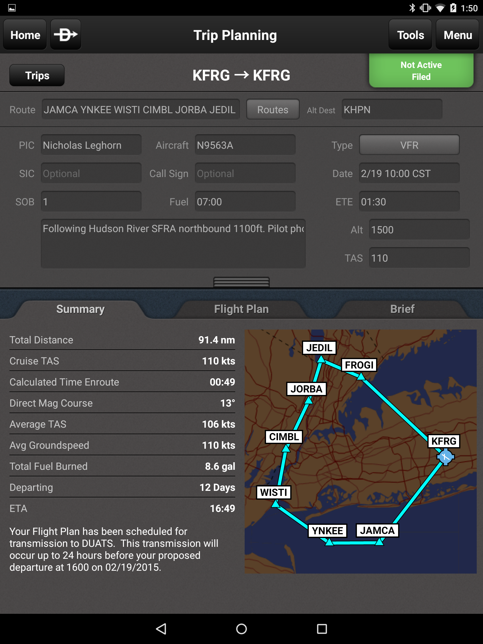
KFRG JAMCA YNKEE WISTI CIMBL JORBA JEDIL FROGI KFRG
My plan was to fly a counter-clockwise circle around the city, and while the SFRA section was easy enough to plan the problem was getting to the entry point. The Bravo around JFK starts at 500 feet, and honestly I wasn’t comfortable flying that low in a rented airplane. So instead I planned for 1,000 feet just outside the edge of that 8 nautical mile circle. The route was a little more circuitous, but it kept me clear of the Bravo and that made me happy.
While that was the plan, I’m hoping to get a more direct routing. Depending on the traffic for JFK that day, I’m planning on asking the approach controller if I can scoot through the Bravo hugging the shoreline at 1,000 feet to stay closer to land in case of any issues. I’m not counting on it though, but fingers crossed.
Coming back across the Long Island Sound will be more of a straight shot. Once I’m in the groove for the SFRA, I’m stuck until I hit the Alpine Tower checkpoint near the Tappan Zee bridge. Exiting prior to that point will stick me in the Bravo airspace and definitely not in the good graces of the FAA. While Alpine Tower is a little further than I’d like, its not the end of the world. A slight deviation around the LGA Bravo north of New Rochelle and I’m practically home free.
The overall plan is to stay at 1,100 (ish) feet the whole time. That puts me under the Bravo shelf coming out past JFK, and under the shelf past LGA, as well as perfectly within the SFRA transient operations layer. All I need to do is set that altitude, trim the airplane, and just worry about navigating. One less thing to worry about is definitely helpful in that situation.
As planned, my total time en route is about an hour and a half. Garmin says that it will only be about an hour, but I’m planning on sliding the throttle back and possibly throwing out some flaps while passing the city for a better view.
In the cockpit, I’m definitely going to bring the MyGoFlight mount and my Nexus 9 tablet with Garmin Pilot installed. I’ve had some actual IFR instrument time lately and used that setup for backup navigation and situational awareness, and the thing is dead nuts accurate. In fact, it seemed more accurate than the HSI in the 172 I was flying. The Cessna on loan is a round dial model, and while they have a G1000 equipped plane available sadly I’m not yet checked out in that cockpit. So having a GPS for reference will help keep me out of the Bravo airspace and squeaky clean legal.
Something else I’m bringing in the cockpit: a friend. She thinks I’m giving her a ride because she’s special, and that’s partially true, but really she’s there to do everything I can’t. Due to the complex airspace and the tight line I need to fly I want to focus on flying the airplane and nothing else, but that means I’m going to miss out on a lot of sightseeing. By bringing her along she can be my memory maker, working the camera and taking all the (non-selfie related) photos that I’d want to share afterwards. Plus, she really seemed to love when I brought her along when me and my CFI did one last night flight, so I think she’ll get a kick out of it.
That’s the plan, at least. Here’s how things actually went.
Nice post, how did the flight end up?
I’m planning on flying the corridor this summer!