My girlfriend and I had just spent a week in Cape Cod visiting friends and family. It was our first long distance flight in my Piper Cherokee, and things had gone fairly smoothly so far. I had made the trip the previous year and learned from the mistakes I made, ensuring that this time I brought a tarp to cover the airplane and prevent the water logged radios that plagued me on the last trip. But on the flight back things were about to get much more interesting.
Flight Planning
We were both due back at work in a couple days time, but we had left ourselves enough room in the schedule to head back to Austin via Chicago to see my sister. Our plan was to bring her some pastries from our favorite French bakery on the cape — PB Boulangerie — that might still be fresh by the time we land in Chicago. Unless we decided to eat them during the flight, that is.
The Piper Cherokee I owned at the time had a fairly good range, but not enough to make it to Chicago from Cape Cod in one hop. The maximum fuel endurance for the Cherokee is about five hours, but when you add in the IFR fuel minimums and the endurance of our bladders that comes much closer to four hours at the most.
I planned to make a fuel stop in Bradford Pennsylvania, a small regional airport four hours away with an instrument approach close enough to the great lakes to be a good chunk of the flying for the day but far enough away that the local weather should still be good. From there I would fly across the base of Michigan for another four hours and land at Chicago Executive north of the city. Each leg well within the endurance and IFR fuel minimums of the aircraft. Theoretically.
Pre-Flight
During the week we kept an eye on the weather, and things seemed okay. Not great, but okay. The day after we were to depart there was a storm system forecast to move across our flight path, but we figured that we would be already southbound from Chicago by the time it arrived.
On the morning of the flight the weather was looking less than perfect, but it was still within my minimums. The forecast summer storm system that we had been watching was indeed working its way across the middle of the country. The weather forecast for Chicago had changed to be below VFR minimums at our time of arrival, but with the worst of the cloud bases over 1,300 feet AGL I was happy that I could make an instrument approach and complete the flight.
Wanting to beat the weather to our destination we loaded up the airplane early in the morning, said our goodbyes to the family, and started flying westbound.
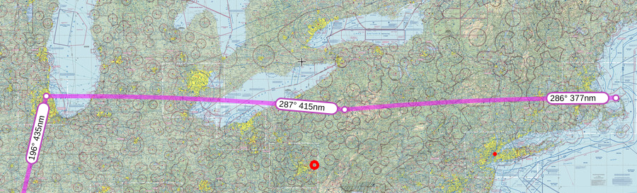
KPCV -> KBFD (377 NM)
The first leg of the flight was uneventful except for one small detail: headwinds. The storm system that was coming our way also came with some fairly strong headwinds that dropped our ground speed by about 20 knots. We arrived in Bradford a little behind schedule but still within the margin of error for the day.
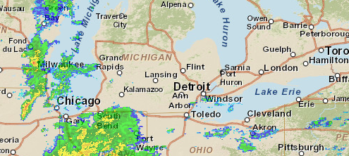
Sitting on the ground in Bradford I took another look at the weather forecast for the next leg of the trip. The terminal forecast hadn’t changed, but the storm had developed significantly since the beginning of the day. There were now two “wings” of the storm — a southern end that was moving rapidly to the northeast, and a northern end that seemed to be losing steam. There was a gap between the two right over Chicago.
Even with this new information I wasn’t concerned enough to cancel the flight. We had a dinner planned with my sister in Chicago that night which provided some additional “get-there-itis” force and with about two hours of extra fuel in the tanks and plenty of diversion airports available along the route I was happy that there would be time for me to troubleshoot any issue we may come across. Once I paid for the fuel at the FBO we hopped back in the airplane and started heading out over Lake Erie.
KBFD -> KPWK (415 NM)
The flight over Lake Erie was absolutely beautiful. There were some clouds on the horizon but where we were it was still clear and calm. We transited through Canadian airspace — another first for me on the trip — south of Detroit and picked our way through the busy Class B airspace.
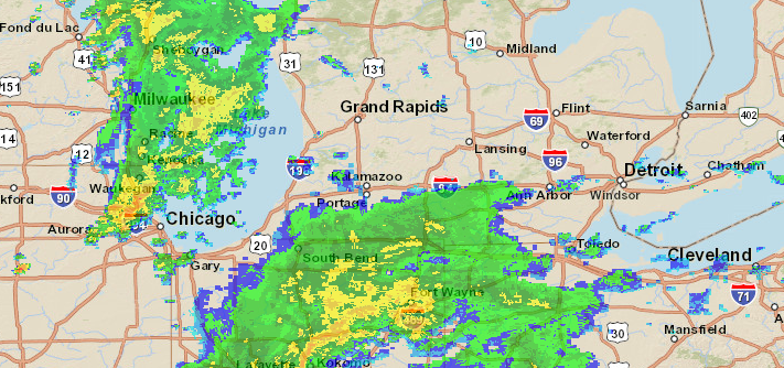
While we were in the air I used my Garmin Pilot and GDL-39 to keep an eye on the weather developing in front of us. The storm had moved quicker than I was expecting, and our flight path would bring us directly through the outer bands of rain painted on the radar picture.
Wanting to avoid that rain and turbulence as much as possible I asked ATC to help re-route us through Flint and Grand Rapids, hoping to come down the back side of the storm system and slide into Chicago just after the angry orange storms currently overhead had subsided.
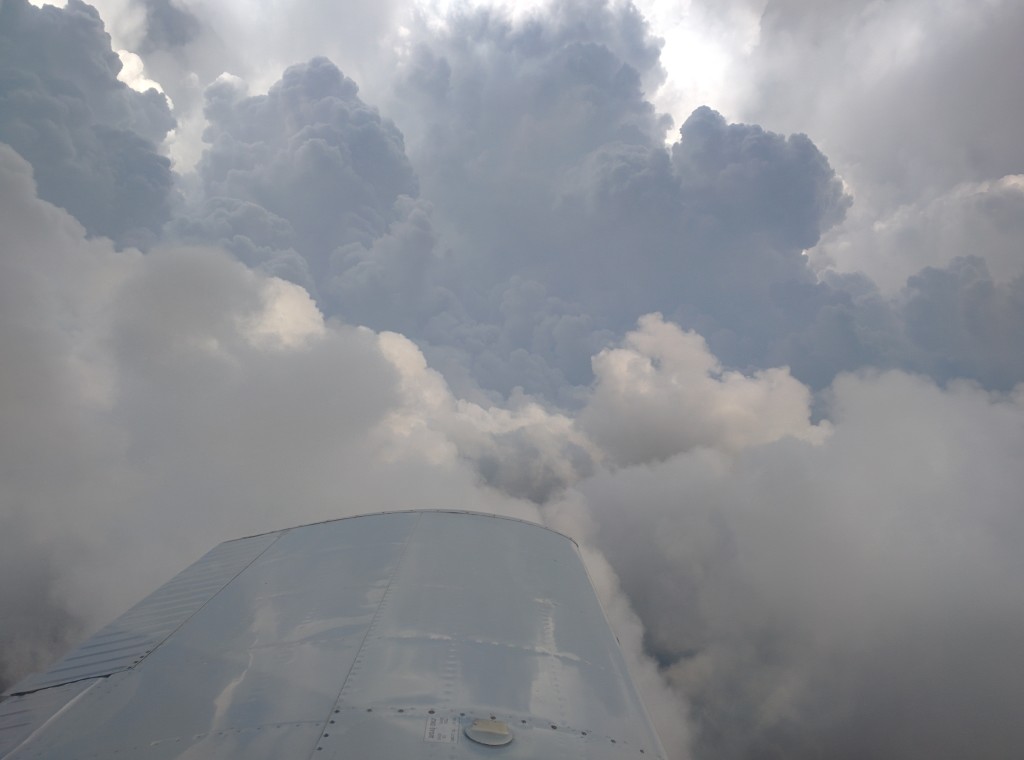
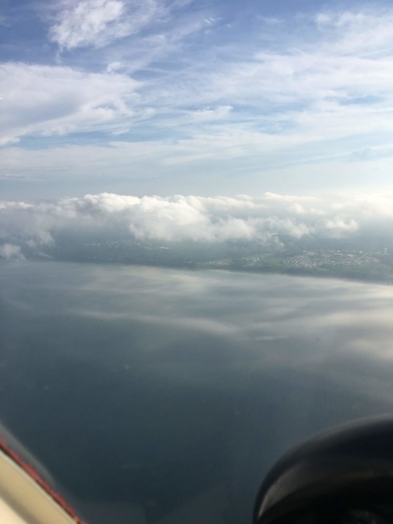
ATC was happy to oblige, and soon we were flying along the trailing edge of the storm and making good time towards Chicago. The video above shows what it was like — there were some clouds scattered around, but in general we had found a clear altitude to cruise at that was smooth and rain free.
As we were handed off to Chicago approach near Kalamazoo we were told to expect a re-route around the south of the lake. Our original IFR clearance had us clipping the bottom of Lake Michigan and flying up the shoreline to Chicago Executive. After punching in the new clearance which took us well south of the lake it added a full extra hour on our intended flight time. Which was concerning.
The biggest issue was that we had been flying for around three and a half hours at this point. By my calculations we were less than an hour from Chicago according to our original flight plan, but that total flight time had been extended thanks to some headwinds over Lake Erie. I was still happy with the fuel situation on the original plan but not the new one.
The frequency wasn’t terribly busy so I called ATC back and asked if we could get our original clearance reinstated. They responded that it simply wasn’t possible, but they had an alternative. I could take a westbound turn RIGHT NOW, fly over the middle of Lake Michigan, and then get routed down the shoreline on the other side. That would be the quickest way to get to my destination, and might actually be faster than the original plan.
I asked for a minute to consider my options.
Option 1: Direct Across the Lake
Lake Michigan is approximately 70 nautical miles wide at the point where we would be crossing. That’s more than 30 minutes of time where I would be outside gliding distance from the shore.
I’ve flown over water before, and we had just flown over an equivalent distance of Lake Erie in our single engine airplane without any issues and (in my mind) an acceptable level of risk. The difference this time was the presence of thunderstorms in the area. I could see on my iPad that the thunderstorm that had been plaguing Chicago all day had indeed moved off the city but was now exhausting its energy on the lake. There were scattered cells of heavy rain all over that area and flying through it would not be pleasant.
While this offered the most direct and quickest route to my destination it was also the most dangerous due to weather.
Option 2: Take the South Diversion Route
According to my calculations I had enough fuel on board to make the airport even with the southbound diversion, but just barely. I would be able to get to the destination and do an approach, but if the weather deteriorated further then I would be out of fuel and out of options. I wouldn’t have enough fuel to get out of that weather system and find a clear airfield to land at.
It was probably the easiest option, since it was already programmed into the iPad and I had already been cleared for the path. There was also the subconscious benefit of not having to “stand up to” ATC and ask for something else, instead submitting to their authority. It even might actually work, so long as nothing else changed and the weather was good at the other end. Which were a lot of assumptions.
Option 3: Diversion
As any private pilot who passed their checkride knows, diversion is always a valid option. In this case I could divert to a local airfield, refuel, and then continue my route around the south of the lake.
This option had a lot of issues, though. The closest airport that I was comfortable landing at was South Bend (KSBN). They were a comfortable distance away to allow for a controlled descent, had an operating control tower, and offered an ILS approach. Which was important, as the current weather for the airport wasn’t conducive to a VFR approach and landing.
KSBN 042154Z 19006KT 10SM BKN011 OVC017 19/17 A2978
Broken clouds at 1,100 feet and a solid overcast layer at 1,700. Not an impossible task, but definitely adding to the stress of a possible diversion. I had been flying for around eight solid hours at that point and I was physically and mentally exhausted. The idea of needing to hand fly an ILS approach to landing (thanks to the antiquated systems in my 1963 Piper Cherokee) was not very appetizing
Other factors influencing my decision was an uncertainty about how long it would take to refuel and be on our way, and some hesitancy to have to file a new flight plan for the remainder of the trip. All minor inconveniences in the stark light of day but they definitely added to the potential stress.
Decision: Divert
After spending a couple seconds considering the options and looking at the weather at surrounding airports I decided to divert into South Bend for fuel before continuing my flight. The trip across Lake Michigan was right out in my mind, the risk of being trapped in one of the storm cells and being forced down over water was too high. And continuing to the destination may have been the most expedient route but wasn’t the most prudent.
After informing ATC of the planned diversion they started vectoring me for the ILS to runway 27 L. We had been cruising along at 4,000 feet, but the approach started at 2,400 feet. Somewhere around 3,000 feet we entered the top of the cloud layer and I was completely IFR, a difficult situation normally made even more so by my fatigue.
One thing I really appreciated from the controllers was that before I was handed off to South Bend Tower the approach controllers offered to file an IFR flight plan for me for the remainder of the journey and have it waiting with the tower by the time I was finished refueling. Even with the high workload of the Chicago airspace and trying to work the existing aircraft around the storms in the area they took the time to help me out and save five minutes of effort on my end. Not something I’d expect on every flight, but on this one it absolutely made my day.
Flight plan on file they handed me off to South Bend tower and cleared me for the approach. It probably wasn’t the prettiest ILS approach I’d ever flown, but just like clockwork we broke out of the bottom layer of clouds around 1,000 feet exactly on glideslope. Following an acceptable landing we taxied to the most convenient FBO, refueled the aircraft, and headed back out to finish the flight.
KSBN -> KPWK (75 NM)
The last leg of the flight was the least eventful. Climbing out of South Bend on our IFR flight plan we were cleared to climb above the cloud layer and were given a great view of Chicago as we were routed around the busy airspace. Thanks to all of the delays and the diversion earlier in the flight we had successfully waited out the storm and all that remained were a couple lingering clouds above the city.
Coming into Chicago Executive the weather was clear enough for a visual approach and landing, but instead I decided to perform the VOR approach to runway 16. It wasn’t technically necessary, but I wasn’t feeling as exhausted as over South Bend and wanted to get one more approach on my logbook. After a textbook perfect course reversal and approach we touched down and headed off to the hotel for the night.
Conclusion
We missed dinner with my sister that night. By the time we made it to the hotel we were simply too exhausted to go anywhere else. Instead she came to us, we had some beers in the hotel bar, and successfully delivered the pastries to her less than 12 hours after they were made in Cape Cod, Massachusetts.
In retrospect the smarter move may have been to abandon the second leg of that day’s flight back at Bradford. With the weather deteriorating and the already problematic headwinds it would have been smarter to find a local airfield that had a nearby hotel and get a good night’s rest before immediately returning to Texas and abandon the idea of making it to Chicago. But with the added pressure of an existing dinner appointment and wanting to give my passenger the best flight possible I decided to push through anyway, accepting the higher risk given the higher rewards.
There’s not a doubt in my mind that I would have been completely screwed if I had only taken paper charts. The real time weather information provided by Garmin Pilot and the GDL-39 (although I would probably get the GDL 50 these days) enabled me to know where the weather was, how it was moving, and stay one step ahead at all times. I also probably wouldn’t have even known about the ILS approach into South Bend let alone been able to perform it, but thanks to the tablet I always have every approach plate for every airport in the United States at my fingertips.
Three things to take away from my experience:
- Always bring a tablet (like this cheap refurbished iPad) with your choice of aviation software and have some form of live weather data when performing long cross country flights.
- Bring every spare drop of fuel you can afford. And when flight planning, add a little extra time to the FAA required minimums for safety.
- Be mentally prepared to cancel the flight at any time, and be prepared to stay overnight if needed. I’ve had great success with Hotels.com and their app, even getting great deals on last minute hotels when I’ve found myself stranded somewhere I didn’t intend to be that night.